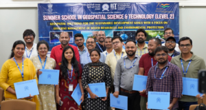
 Dhanbad: The Twenty One Day Summer School in Geospatial Science & Technology (Level 2) concluded today at IIT (ISM), with 22 participants commending the organizers for significantly enhancing their technical skills in various geospatial tools and techniques.
Organized by the Department of Civil Engineering in collaboration with the Department of Environmental Science & Engineering and the Centre for Water Resource Management, the summer school was held from June 14 to July 4, 2024, at the Executive Development Centre of IIT (ISM).
The participants, including faculty members, research scholars, industry professionals, project assistants, teachers, and NGO members from across the country, praised the program for its comprehensive training.
Professor Sukumar Mishra, Director of IIT (ISM), addressed the Valedictory Function as the Chief Guest. He emphasized the importance of the IoT-based approach taught during the program, stating, “The IoT-based approach taught in the 21-day summer school will generate significant data, and over the past three weeks, you have learned how to capture and extract valuable information from this data.”
He further highlighted the potential of India’s move towards NAVIK for geopositioning and other applications, despite the preparatory work required for its full adoption.
Professor Srinivas Pasupuleti, Head of the Department of Civil Engineering and Principal Investigator of the project, delivered the welcome address.
He noted that the three-week program included 66 sessions—48 lectures and 18 practical sessions—alongside project work focused on Sustainable Development Goals. “The course aimed to enhance participants’ technical skills in geospatial science and technology using open-source software through hands-on sessions,” he explained.
“It also sought to address Sustainable Development Goals in the Indian context with geospatial technologies.”
Professor Pasupuleti highlighted that the summer school provided a thorough introduction to both fundamental and advanced geoinformatics concepts, demonstrating how geospatial techniques can effectively address real-world problems and support stakeholders, managers, and policymakers in sustainable development.
Professor SR Samadder, Co-Principal Investigator of the project, delivered the vote of thanks and announced plans to conduct Level 1 training next year.


